Port Information
Overview
Leading future, Buautiful Jeju port
Located at the southeast end of the Korean peninsula, Busan Port is Korea’s number one port, acting as a gateway to connect the Pacific and the Asian continent,
and is responsible for 34% sea freight exports, 75% of container cargo, and handles 13% of marine goods produced in Korea. The port is subdivided into North Port, Gamcheon Port, New Port, and Dadaepo Port.
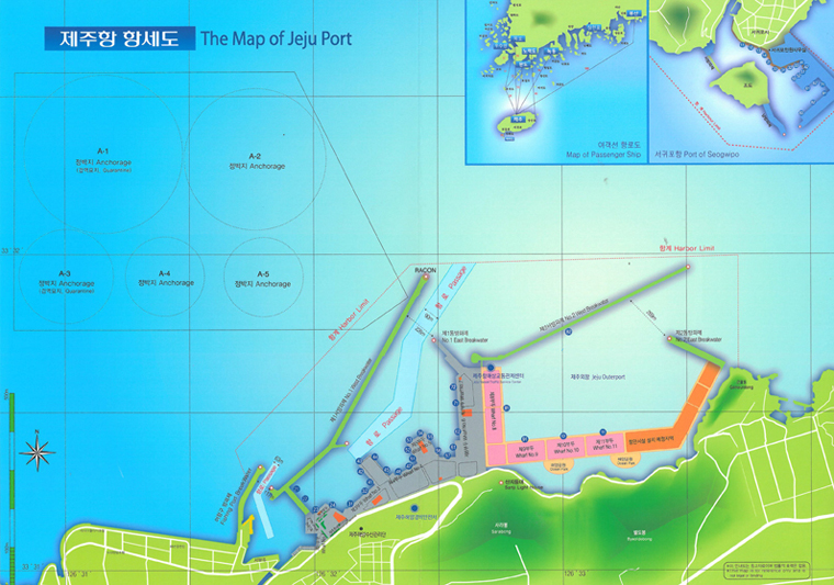
Geographical conditions and status
- Jeju Port, situated in the north certer of Jeju-do (Island), has implemented the role of logistic center and tourism supporting port of Jeju area since its opening in July 1927.
- For the trouble-free management of vessels and freight entering and departing the port, Jeju Port is equipped with speedy administration support system including Port Management Information System (PORT-MIS) and Vessel Traffic Service (VTS). Jeju Inner Port is a multi-functional port dealing with commodities, tangerines, etc based on implementation of Jeju Free International City. Jeju Outer Port will be developed as an international tourism port considering its excellent scenery.
Current development of port facilities
- Busan Port first opened in the name of “Busanpo” in 1876, commenced its first dock construction in 1906, and has since developed into a modernized port consisting of a total of 4 ports (North Port, Gamcheon Port, New Port, and Dadaepo Port), and 9 container terminals and international passenger terminals. Jeju Port is the gate port of Jeju Special Self-Governing Province, and coastal liners connecting the Korean mainland converge here. Recently with increase of international cruise ship’s entry to the port, it is developing as an international tourism port.
Harbor limit
- The surface of the sea within the line connecting from the starting point of West Breakwater to north latitude (NL) 33°31’21.70“ and east longitude (EL) 126°31’39.69” point, NL 33°31’58.70“ and EL 126°32’20.69” point, NL 33°31’59.70“ and EL 126°33’43.68” point, and the northern end of Goneuldong consecutively.
| Water Area | Tidal Changes | Length of Coastline | Water Depth |
|---|---|---|---|
| 3,540㎢ | 2.1m | 3㎞ | (-)2m ~ (-)11m |
Port Jeju
| Classification | Inner Port Upper Sector | |||||||||||
|---|---|---|---|---|---|---|---|---|---|---|---|---|
| Quay 1 | Quay 2 | Quay 3 | Quay 4 | |||||||||
| (lighters wharf 329m) | (quay wall 410m) | (quay wall 230m) | (quay wall 410m) | |||||||||
| Spec. | Quay length | 74 | 255 | 100 | 85 | 105 | 120 | 230 | 165 | 100 | 180 | 160 |
| Water level (m) | 3 | 3 | - | - | 6 | 6.5 | 6.4 | 7.5 | 7.5 | 8 | 6 | |
| Cargo handling capacity | - | - | - | - | - | - | 517 | - | - | - | - | |
| Concurrent berthing capacity | - | - | 50 Ton | 250 Ton | 3,000 Ton | 3,000 Ton | 3,000 Ton | 5,000 Ton | 5,000 Ton | 8,000 Ton | 3,000 Ton | |
| 4vssl | 1vssl | 1vssl | 1vssl | 2vssl | 1vssl | 1vssl | 1vssl | 1vssl | ||||
| Classification | Inner Port Upper Sector | |||||||||||
|---|---|---|---|---|---|---|---|---|---|---|---|---|
| Quay 5 | Quay 6 | Quay 7 | Police Quay | |||||||||
| (lighters wharf 545m) | (quay wall 305m) | (quay wall 195m) | (quay wall 135m) | |||||||||
| Spec. | Quay length | 140 | 140 | 110 | 70 | 85 | 100 | 205 | 195 | 135 | ||
| Water level (m) | 6 | 7.5 | 6 | 5 | 5 | 5 | 8 | 11 | 11 | |||
| Cargo handling capacity | 312 | 336 | 336 | 246 | 246 | - | - | - | - | |||
| Concurrent berthing capacity | 3,000 Ton | 5,000 Ton | 10,000 Ton | 1,000 Ton | 1,000 Ton | 1,000 Ton | 10,000 Ton | 20,000 Ton | 3,000 Ton | |||
| 1vssl | 1vssl | 1vssl | 1vssl | 1vssl | 1vssl | 1vssl | 1vssl | 1vssl | ||||
Jeju Outer Port
| Classification | Jeju Outer Port | |||||
|---|---|---|---|---|---|---|
| Quay 8 | Quay 9 | Quay 10 | Quay 11 | |||
| (quay wall 390m) | (quay wall 210m) | (quay wall 210m) | (quay wall 210m) | |||
| Spec. | Quay length | 390 | 310 | 210 | 210 | 210 |
| Water level (m) | 12 | 11.5 | 12 | 12 | 12 | |
| Cargo handling capacity | - | - | 628 | 628 | 1,004 | |
| Concurrent berthing capacity | 80,000 Ton 1 vssl |
50,000 Ton 1 vssl |
20,000 Ton 1 vssl |
20,000 Ton 1 vssl |
20,000 Ton 1 vssl |
|
Seogwipo Port
| Classification | Seogwipo Port | |||||||||||
|---|---|---|---|---|---|---|---|---|---|---|---|---|
| Quay 1 | Quay 2 | Quay 3 | Quay 4 | |||||||||
| (lighters wharf 390m) | (quay wall 210m) | (quay wall 210m) | (quay wall 210m) | |||||||||
| Spec. | Quay length | 178 | 178 | 178 | 70 | 70 | 90 | 180 | 180 | 180 | 150 | 150 |
| Water level (m) | 3 | 3 | 3 | 4.5 | 5 | 5.5 | 6 | 6 | 6 | 6 | 6 | |
| Cargo handling capacity | - | - | - | - | 102 | 102 | - | - | - | - | - | |
| Concurrent berthing capacity | - | - | - | 300 Ton | 1,000 Ton | 2,000 Ton | 5,000 Ton | 5,000 Ton | 5,000 Ton | 3,000 Ton | 3,000 Ton | |
| 1vssl | 1vssl | 1vssl | 1vssl | 1vssl | 1vssl | 1vssl | 1vssl | |||||
| Classification | Seogwipo Port | |||||||||
|---|---|---|---|---|---|---|---|---|---|---|
| Quay 5 | Quay 6 | Quay 7 | Quay 8 | |||||||
| (lighters wharf 390m) | (quay wall 210m) | (quay wall 210m) | (quay wall 210m) | |||||||
| Spec. | Quay length | 140 | 140 | 70 | 115 | 115 | 140 | 100 | 100 | 140 |
| Water level (m) | 6 | 6 | 6 | 7.5 | 7.5 | 7.5 | 7.5 | 7.5 | 9.5 | |
| Cargo handling capacity | 102 | 102 | - | 196 | 196 | 102 | - | - | 135 | |
| Concurrent berthing capacity | 3,000 Ton | 3,000 Ton | 500 Ton | 3,000 Ton | 3,000 Ton | 3,000 Ton | 3,000 Ton | 3,000 Ton | 5,000 Ton | |
| 1vssl | 1vssl | 1vssl | 1vssl | 1vssl | 1vssl | 1vssl | 1vssl | 1vssl | ||